
Australian New Guinea
| Full Name | 72 Territory of New Guinea | |
| Alliance | Allies - Minor Member Nation or Possession | |
| Possessing Power | Australia | |
| Entry into WW2 | 3 Sep 1939 |
Contributor: C. Peter Chen
ww2dbasePrior to WW1, the northeastern quarter of the island of New Guinea was under German control. In 1919, a League of Nations Mandate was created, assigning this territory under Australian care. The Australians established the capital of the Australian Territory of New Guinea at Rabaul on the island of New Britain in the nearby Bismarck Archipelago. Rabaul was chosen for this role largely due to its useful deep-water anchorage, Simpson Harbor. In the opening chapters of the Pacific War, Japanese troops captured New Britain and New Ireland in Jan 1942. Initially, Rabaul was but a remote provincial town; famed Japanese naval aviator Saburo Sakai, who had arrived at Rabaul shortly after the conquest, made the following observation regarding his new base, the Vunakanau airfield.
ww2dbaseDespite the harsh terrain, by 1943, Rabaul was protected by almost 100 Type 88 and Type 99 anti-aircraft guns, about 24 120-millimeter or larger dual-purpose guns, 38 120-millimeter or larger coastal guns, about 100 Type 96 25-millimeter auto-cannon, more than 50 heavy machine guns, and about 120 light machine guns; all of the above were deployed by the Japanese Navy. The Japanese Army added 150 howitzers, 75 infantry guns, mortars, anti-tank guns, and over 600 machine guns and grenade launchers. Underneath the surface, 300 miles of tunnels and caves were dug around the rim of the caldera between late 1943 and early 1945; a navy hospital of 1,000 beds, an army hospital of 4,000 beds, command posts, barracks, storage spaces for landing craft, and other facilities were established underground (thousands of Indian and Chinese conscripts and laborers died excavating these tunnels and caves). Outside Simpson Harbor, extensive mine fields guarded against any potential enemy approaches by sea. On land, water production was increased to 290,000 gallons per day with 13 new wells. Power generation was dramatically increased with 23 generators. Six months worth of food was stockpiled at various locations on the island of New Britain. Newly arrived radar systems were probably among the most important additions. In short, the Japanese had built Rabaul, and the island of New Britain overall, into a formidable fortress. Offensively, Simpson Harbor allowed Rabaul to become a jump off point for offensives to the south. It was Rabaul that hosted the build up for the offensives that resulted in the Battle of the Coral Sea, the amphibious landings on mainland New Guinea island, and the aerial bombing campaign of Port Moresby, the capital of Australian Territory of Papua on the southern side of New Guinea island. The civilian population of Rabaul grew along with the military expansion; by early 1944, and estimated 15,000 Japanese civilians lived in and near Rabaul, providing various types of commercial, financial, and other services for the servicemen.
ww2dbaseIn Sep 1943, the Imperial General Headquarters in Tokyo, Japan endorsed a plan to reduce Japan's defense perimeter; the Territory of New Guinea fell outside of this new perimeter. Through 1944, US amphibious attacks slowly secured strategic coastal points one by one. Aitape in Territory of New Guinea and Hollandia in Dutch New Guinea (the western half of New Guinea island) were generally conquered by Aug 1944, thus marking the end of effective Japanese resistance in the eastern half of New Guinea, although small pockets of resistance would remain through the very end of the Pacific War. Rabaul, indeed formidable, was blockaded and bypassed by the Allies. Already frustrated by regular Allied bombings and already plagued by various diseases such as malaria, dengue fever, and chronic diarrhea, the Japanese personnel trapped at Rabaul would also experience a severe lack of food toward the final months of the war.
ww2dbaseIn 1942, the Australian New Guinea Administrative Unit was formed to provide efficient war-time civilian leadership over both the Territory of New Guinea and Australian Papua. After the war, the Papua New Guinea Provisional Administration Act of 1945-1946 was passed, officially creating a single administrative body, although the two territories were still separate. In 1949, the Papua and New Guinea Act was passed, creating a single entity named the Territory of Papua and New Guinea. In 1972, self government was granted, leading up to the 1975 independence of the nation of Papua New Guinea.
ww2dbaseSources:
Bruce Gamble, Fortress Rabaul
Bruce Gamble, Target Rabaul
Wikipedia
Last Major Update: Apr 2013
| Events Taken Place in Australian New Guinea | ||
| New Guinea-Papua Campaign, Phase 1, Bismarck Islands | 20 Jan 1942 - 24 Jan 1942 | |
| New Guinea-Papua Campaign, Phase 2 | 8 Mar 1942 - 4 Mar 1943 | |
| Solomon Islands Campaign | 23 Aug 1942 - 25 Dec 1943 | |
| New Guinea-Papua Campaign, Phase 3 | 30 Sep 1943 - 23 May 1945 | |
| Japan's Surrender | 14 Aug 1945 - 2 Sep 1945 | |
| Facilities | ||
| Nadzab Airfield | Air Base | |
| Saidor Airfield | Air Base | |
Weather
WW2-Era Weather Data for Australian New Guinea
Photographs
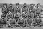 | 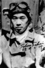 | 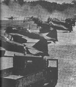 | 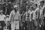 |
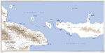 |  |  |
Australian New Guinea in World War II Interactive Map
Did you enjoy this article or find this article helpful? If so, please consider supporting us on Patreon. Even $1 per month will go a long way! Thank you. Share this article with your friends: Stay updated with WW2DB: |
- » WW2DB's 19th Anniversary (29 Dec 2023)
- » Looted Painting "Madonna with Child" Returned to Poland (2 Jun 2023)
- » Wreck of USS Mannert L. Abele Found (29 May 2023)
- » Wreck of Montevideo Maru Found (25 Apr 2023)
- » Accidental Detonation of a WW2-Era Bomb in Great Yarmouth (10 Feb 2023)
- » See all news
|
- » 1,146 biographies
- » 336 events
- » 43,422 timeline entries
- » 1,237 ships
- » 349 aircraft models
- » 207 vehicle models
- » 372 weapon models
- » 123 historical documents
- » 259 facilities
- » 468 book reviews
- » 28,395 photos
- » 432 maps
Winston Churchill
Please consider supporting us on Patreon. Even $1 a month will go a long way. Thank you!
Or, please support us by purchasing some WW2DB merchandise at TeeSpring, Thank you!