432 items in this album on 22 pages.
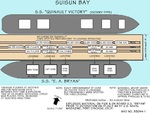 | 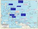 | 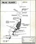 | 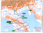 |
| Diagram taken from the Navy report showing the ships and pier at the center of the Port Chicago munitions explosion, 17 Jul 1944. Note that the tonnages listed are as of 6 hours prior to the explosion. | Map depicting Allied advances in the southwestern Pacific Ocean area, 30 Jul-22 Sep 1944 | Map of the Palau Islands, 1944 | Map showing the Allied advance toward and through the Gothic Line, Italy, 5 Jun-31 Dec 1944 |
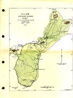 | 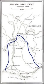 | 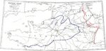 | 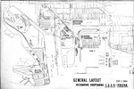 |
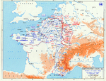
| US Navy Construction Brigade Sept 1944 map of Guam in the Mariana Islands highlighting the newly constructed airfields | Map depicting the US 7th Army's front in Southern France, 1 Sep 1944 | Map depicting the western front of the European War, 1 Sep 1944 | Sep 1944 map showing the general layout of Kaiser Richmond Shipyards Nos. 1, 2, 3, and 4 plus the prefabrication shops, Richmond, California, United States. |
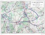 | 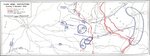 | 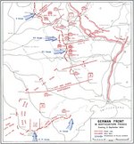 | 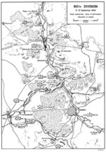 |
| Map showing the plan of attack for US Army XII Corps on the city of Nancy, France, Sep 4, 1944. | Map depicting the dispositions of the US 3rd Army at the evening of 5 Sep 1944 | Map depicting the German front in Northeastern France, 5 Sep 1944 | Map showing the plan of attack for US Army 80th Division on the city of Nancy, France, Sep 5-10, 1944. |
 | 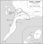 | 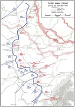 |  |
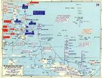
| Map depicting the Allied campaign toward Germany, 26 Aug-14 Sep 1944 | Map showing the Morotai landings on 15 Sep 1944 | Map depicting the US 3rd Army's front lines at the evening of 25 Sep 1944 | Map showing Japanese defensive plan at Peleliu |
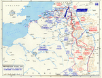 | 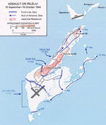 | 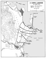 |  |
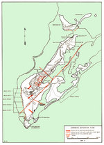
| Map noting the front lines of the Western Front of European War and the Operation Market Garden offensive, 15 Sep-15 Dec 1944 | Map depicting the American assault on Peleliu, Palau Islands, 15 Sep-15 Oct 1944 | Map of the Leyte landing beaches, 20 Oct 1944 | Map depicting the American invasion of Leyte and the Leyte Gulf battles in the Philippine Islands, 17-25 Oct 1944 |
432 items in this album on 22 pages.
Search WW2DB
News
- » WW2DB's 19th Anniversary (29 Dec 2023)
- » Looted Painting "Madonna with Child" Returned to Poland (2 Jun 2023)
- » Wreck of USS Mannert L. Abele Found (29 May 2023)
- » Wreck of Montevideo Maru Found (25 Apr 2023)
- » Accidental Detonation of a WW2-Era Bomb in Great Yarmouth (10 Feb 2023)
- » See all news
Current Site Statistics
- » 1,146 biographies
- » 336 events
- » 43,422 timeline entries
- » 1,237 ships
- » 349 aircraft models
- » 207 vehicle models
- » 372 weapon models
- » 123 historical documents
- » 259 facilities
- » 468 book reviews
- » 28,395 photos
- » 432 maps
Famous WW2 Quote
"An appeaser is one who feeds a crocodile, hoping it will eat him last."Winston Churchill
Support Us
Please consider supporting us on Patreon. Even $1 a month will go a long way. Thank you!
Or, please support us by purchasing some WW2DB merchandise at TeeSpring, Thank you!