169 items in this album on 9 pages.
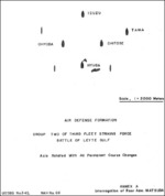 |  | 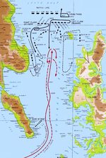 |  |
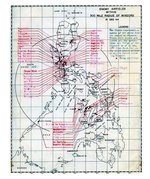
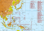
| Drawing of the air defense formation of Group Two of Japanese Navy 3rd Fleet Striking Force during Battle off Cape Engaño, 25 Oct 1944; appendix A of Rear Admiral Chiaki Matsuda's interrogation | Map depicting fleet movements during the Battle of Leyte Gulf, 24-25 Oct 1944 | Map depicting fleet movements during the Battle of Surigao Strait, 25 Oct 1944 | Map depicting fleet movements during the Battle off Samar, 25 Oct 1944 |
 |  |  |  |
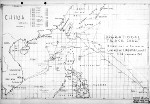
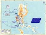
| Sketch excerpted from USS St. Louis’s action report showing paths of nine special attack planes that dived on the ship in Leyte Gulf, Philippines, 27 Nov 1944. | Map depicting US 6th Army operations at Leyte and Samar, Philippine Islands, 17 Oct-30 Dec 1944 | US Navy 1944 berthing chart for the Northern Anchorage of the Ulithi Lagoon, Caroline Islands | United States Army map showing all identified Japanese airfields within 300 miles of the Philippine island of Mindoro. This map was prepared as part of the Mindoro invasion plans, 15 Dec 1944. |
 | 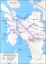 | 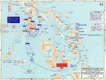 |  |
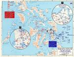
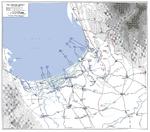
| Task Force 38 operational track for Operation Gratitude into the South China Sea, Dec 30, 1944 through Jan 26, 1945. | US map of the situation on Leyte, Philippine Islands, as of 31 Dec 1944 | Map depicting the campaign in the Philippine Islands, 13 Dec 1944-24 Jan 1945 | Map of major Pacific War engagements, 1942-1945 |
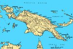 |  |  | 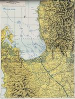 |
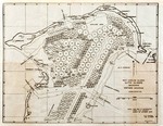
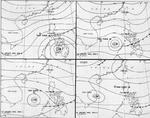
| Map of New Guinea, showing major coastal strategic regions | Four-part weather map of the South China Sea for Jan 7 to 10, 1945. Note daily positions of Task Force 38. | Map of landing beaches in Lingayen Gulf, Luzon, Philippine Islands, 9 Jan 1945 | United States Army operations map of Lingayen Gulf, Luzon, Philippines showing the Landing beaches for the 9 Jan 1945 landings. |
 | 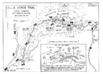 |  |  |
| Four-part weather map of the South China Sea for Jan 11 to 14, 1945. Note daily positions of Task Force 38. | Map of the Villa Verde trail used by the US 32nd Infantry Division during the Luzon Campaign, Jan 30 through May 28, 1945 | Map of the American campaign on Luzon, Philippine Islands, 9 Jan-4 Feb 1945 | Contour map of Iwo Jima, showing Japanese defense installations as observed from ground study during the period of 19 Feb-19 Mar 1945, map 1 of 2 |
169 items in this album on 9 pages.
Search WW2DB
News
- » WW2DB's 19th Anniversary (29 Dec 2023)
- » Looted Painting "Madonna with Child" Returned to Poland (2 Jun 2023)
- » Wreck of USS Mannert L. Abele Found (29 May 2023)
- » Wreck of Montevideo Maru Found (25 Apr 2023)
- » Accidental Detonation of a WW2-Era Bomb in Great Yarmouth (10 Feb 2023)
- » See all news
Current Site Statistics
- » 1,146 biographies
- » 336 events
- » 43,422 timeline entries
- » 1,237 ships
- » 349 aircraft models
- » 207 vehicle models
- » 372 weapon models
- » 123 historical documents
- » 259 facilities
- » 468 book reviews
- » 28,395 photos
- » 432 maps
Famous WW2 Quote
"You ask, what is our aim? I can answer in one word. It is victory. Victory at all costs. Victory in spite of all terrors. Victory, however long and hard the road may be, for without victory there is no survival."Winston Churchill
Support Us
Please consider supporting us on Patreon. Even $1 a month will go a long way. Thank you!
Or, please support us by purchasing some WW2DB merchandise at TeeSpring, Thank you!