Hozan Airfield
| Type | 136 Air Base | |
| Historical Name of Location | Takao, Takao, Taiwan | |
| Coordinates | 22.635243000, 120.406122000 |
Contributor: C. Peter Chen
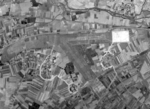
ww2dbaseThe military Hozan Airfield in Takao (now Fengshan, Kaohsiung), southern Taiwan was a small military base consisted of two airstrips carved out of farmland. It provided aerial defense against nearby military wireless station and heavy industries.
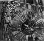
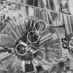
ww2dbaseThe transmitter at the nearby wireless station was one of the largest and most powerful transmitters operated by Japan. The five lattice masts are 350 feet or more in height, and masts were spaced about 1,000 feet apart. 54 tuning houses form a circular perimeter around the main structures.
ww2dbaseAfter the war, the airstrips were removed, returning the land to agricultural use.
Last Major Update: Jan 2015
Hozan Airfield Interactive Map
Photographs
 |  |  |  |
Please consider supporting us on Patreon. Even $1 per month will go a long way! Thank you. Please help us spread the word: Stay updated with WW2DB: |

Takao, Takao, Taiwan
Latitude-Longitude:
22.6352, 120.4061
- » 1,177 biographies
- » 337 events
- » 44,933 timeline entries
- » 1,245 ships
- » 350 aircraft models
- » 207 vehicle models
- » 376 weapon models
- » 123 historical documents
- » 261 facilities
- » 470 book reviews
- » 28,474 photos
- » 365 maps
General Douglas MacArthur at Leyte, 17 Oct 1944
Please consider supporting us on Patreon. Even $1 a month will go a long way. Thank you!
Or, please support us by purchasing some WW2DB merchandise at TeeSpring, Thank you!