| Historical Information | ||||||
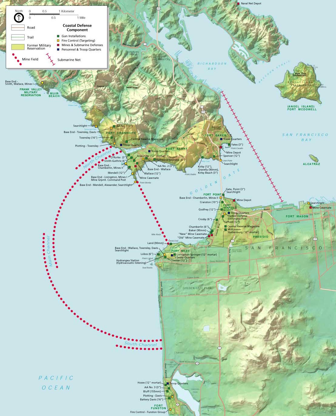
| Caption | National Park Service map of World War II harbor defenses for San Francisco Bay, 2015. Note the location of the Tiburon Naval Net Depot in the upper right. ww2dbase | |||||
| WW2-Era Location Name | San Francisco Bay, California, United States | |||||
| Date | 2015 | |||||
| Photographer | Unknown | |||||
| Source Information | ||||||
| Source | ww2dbaseUnited States National Park Service | |||||
| Related Content | ||||||
| More on... |
| |||||
| Licensing Information | ||||||
| Licensing | This work is believed to be in the public domain. Please contact us regarding any inaccuracies with the above information. Thank you. |
|||||
| Metadata | ||||||
| Added By | David Stubblebine | |||||
| Photo Size | 1,108 x 1,371 pixels | |||||
Please consider supporting us on Patreon. Even $1 per month will go a long way! Thank you. Please help us spread the word: Stay updated with WW2DB: |
Visitor Submitted Comments
All visitor submitted comments are opinions of those making the submissions and do not reflect views of WW2DB.
Search WW2DB
Map
WW2-Era Location Name:San Francisco Bay, California, United States
Latitude-Longitude:
37.8093, -122.4698
Current Site Statistics
- » 1,169 biographies
- » 337 events
- » 44,828 timeline entries
- » 1,244 ships
- » 350 aircraft models
- » 207 vehicle models
- » 376 weapon models
- » 123 historical documents
- » 261 facilities
- » 470 book reviews
- » 28,520 photos
- » 365 maps
Famous WW2 Quote
"All that silly talk about the advance of science and such leaves me cold. Give me peace and a retarded science."Thomas Dodd, late 1945
Support Us
Please consider supporting us on Patreon. Even $1 a month will go a long way. Thank you!
Or, please support us by purchasing some WW2DB merchandise at TeeSpring, Thank you!
6 Apr 2022 12:47:29 PM
Note the location of the submarine net across the channel 1.5 miles inshore from the Golden Gate Bridge. Note also the two Mine Depots on either side of the Golden Gate just east of the bridge. The location of the Mine Depot on the San Francisco side is now a fishing pier known to this day as Torpedo Wharf.