| Historical Information | |||||
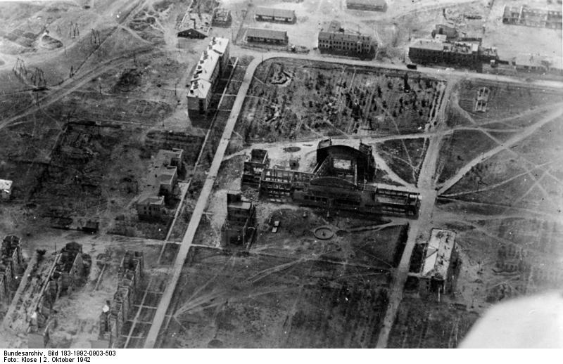
| Caption | Smoke rising from various districts of Stalingrad, Russia, Oct 1942, photo 5 of 5 ww2dbase | ||||
| WW2-Era Location Name | Stalingrad, Russia | ||||
| Date | 2 Oct 1942 | ||||
| Photographer | Klose | ||||
| Source Information | |||||
| Source | ww2dbaseGerman Federal Archives | ||||
| Identification Code | Bild 183-1992-0903-503 | ||||
| Related Content | |||||
| More on... |
| ||||
| Photos in Series | See all 4 photos in this series | ||||
| Photos on Same Day | 2 Oct 1942 | ||||
| Licensing Information | |||||
| Licensing | Creative Commons Attribution ShareAlike 3.0 Germany License (CC BY-SA 3.0 DE).
See Bild 183-1992-0903-503 on Wikimedia Commons According to the German Federal Archive (Bundesarchiv), as of 21 Jul 2010, photographs can be reproduced with if these preconditions are met: - add the signature of the pictures and - of name of the originator, i.e. the photographer. ... You also can use fotos from the Federal Archives for free on Wikimedia Commons https://commons.wikimedia.org/wiki/Commons:Bundesarchiv Please contact us regarding any inaccuracies with the above information. Thank you. |
||||
| Metadata | |||||
| Added By | C. Peter Chen | ||||
| Photo Size | 800 x 518 pixels | ||||
Please consider supporting us on Patreon. Even $1 per month will go a long way! Thank you. Please help us spread the word: Stay updated with WW2DB: |
Visitor Submitted Comments
2. Anonymous says:
7 Apr 2013 07:37:05 AM
--Big complex. --Many buildings not shown here. The Modern Day Location map looks correct. Maybe some of the buildings are still standing.
7 Apr 2013 07:37:05 AM
--Big complex. --Many buildings not shown here. The Modern Day Location map looks correct. Maybe some of the buildings are still standing.
3. Mark Prange says:
7 Apr 2013 12:00:45 PM
Online at "Staloingrad Aerial Scans"--the flight school, barracks, and hangars before and after destruction: GX1567SG-136, GX1885-039, & GX1885-046.
7 Apr 2013 12:00:45 PM
Online at "Staloingrad Aerial Scans"--the flight school, barracks, and hangars before and after destruction: GX1567SG-136, GX1885-039, & GX1885-046.
4. Mark Prange says:
7 Apr 2013 10:58:49 PM
The building with the stark white roof at top left, the E-shaped building in line with it, and the building in the right foreground are still standing. The location pinpointed on the "Modern Day Location" map is too far north. Come south-southeast 1100 meters to find a long red-roofed building (numbered 114); that is the top left building in this WWII photo; the E-shaped building is in plain view, as is the white building across the parking lot.
5. Mark Prange says:
7 Apr 2013 11:25:21 PM
Some of the buildings shown are still standing. The "Modern Day Location" (satellite image) pinpoints too far north; come south-southeast 1100 meters to the long red-roof building (numbered 114); it is the building with the very light-colored roof at the top of the WWII photo; the E-shaped bulding is in line with it; the building across the parking lot is the building in the foreground of the WWII photo.
The flight school, barracks, and hangars can be seen in the online "Stalingrad Aerial Scans"--select TUGX1325SG-057.
6. Mark Prange says:
7 Apr 2013 11:39:25 PM
Some of these buildings are still standing, and can be seen in the "Modern Day Location" satellite image. 100 meters south-southeast of the pinpointed location is a long red-roofed building (numbered 114): that is the building near the top of the WWII photo, left of center. The e-shaped building is in line with it. Across the parking lot is the building which is in the right foreground of the WWII photo.
The flight school, barracks, and hangars can be seen online at "Stalingrad Aerial Scans"--select TUGX1325SG-057.
All visitor submitted comments are opinions of those making the submissions and do not reflect views of WW2DB.
Search WW2DB

Map
WW2-Era Location Name:Stalingrad, Stalingrad, Russia
Latitude-Longitude:
48.7464, 44.4935
Current Site Statistics
- » 1,182 biographies
- » 337 events
- » 45,115 timeline entries
- » 1,248 ships
- » 350 aircraft models
- » 207 vehicle models
- » 376 weapon models
- » 123 historical documents
- » 261 facilities
- » 470 book reviews
- » 28,414 photos
- » 365 maps
Famous WW2 Quote
"No bastard ever won a war by dying for his country. You win the war by making the other poor dumb bastard die for his country!"George Patton, 31 May 1944
Support Us
Please consider supporting us on Patreon. Even $1 a month will go a long way. Thank you!
Or, please support us by purchasing some WW2DB merchandise at TeeSpring, Thank you!
17 Mar 2013 06:10:49 PM
Stalingrad Flight School, 2.3 kilometers west of Mamaev Kurgan.