| Historical Information | |||||
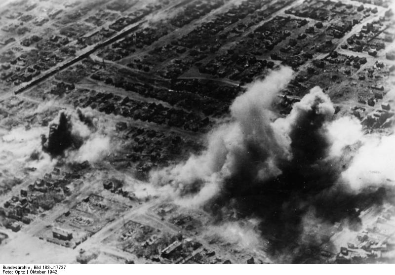
| Caption | Smoke rising from various districts of Stalingrad, Russia, Oct 1942, photo 2 of 5 ww2dbase | ||||
| WW2-Era Location Name | Stalingrad, Russia | ||||
| Date | 2 Oct 1942 | ||||
| Photographer | Opitz | ||||
| Source Information | |||||
| Source | ww2dbaseGerman Federal Archives | ||||
| Identification Code | Bild 183-J17737 | ||||
| Related Content | |||||
| More on... |
| ||||
| Photos in Series | See all 4 photos in this series | ||||
| Photos on Same Day | 2 Oct 1942 | ||||
| Licensing Information | |||||
| Licensing | Creative Commons Attribution ShareAlike 3.0 Germany License (CC BY-SA 3.0 DE).
See Bild 183-J17737 on Wikimedia Commons According to the German Federal Archive (Bundesarchiv), as of 21 Jul 2010, photographs can be reproduced with if these preconditions are met: - add the signature of the pictures and - of name of the originator, i.e. the photographer. ... You also can use fotos from the Federal Archives for free on Wikimedia Commons https://commons.wikimedia.org/wiki/Commons:Bundesarchiv Please contact us regarding any inaccuracies with the above information. Thank you. |
||||
| Metadata | |||||
| Added By | C. Peter Chen | ||||
| Photo Size | 800 x 557 pixels | ||||
Please consider supporting us on Patreon. Even $1 per month will go a long way! Thank you. Please help us spread the word: Stay updated with WW2DB: |
Visitor Submitted Comments
2. Mark Prange says:
16 Mar 2013 07:08:36 PM
Correction: these gullies are west of the Red October factory--not the Barrikady factory.
16 Mar 2013 07:08:36 PM
Correction: these gullies are west of the Red October factory--not the Barrikady factory.
3. Mark Prange says:
7 Apr 2013 07:10:00 AM
In the Modern Day Location map, what is pinpointed is the northern factory grounds of the Red October steel mill. But the area in the photo is in the housing west-northwest of the mill, where there are two gullies. Red October is just out of view to the upper left of the photo. The rail line is not there anymore. When the Red October mill was attacked in earnest part of the German attack was from this neighborhood; in this sector the advance was blocked by Soviet soldiers fighting from behind, on, and under the train.
4. Mark Prange says:
7 Apr 2013 11:49:07 AM
Online at "Stalingrad Aerial Scans" the gullies can be seen. Select GX1915SD-876.
7 Apr 2013 11:49:07 AM
Online at "Stalingrad Aerial Scans" the gullies can be seen. Select GX1915SD-876.
All visitor submitted comments are opinions of those making the submissions and do not reflect views of WW2DB.
Search WW2DB
Map
WW2-Era Location Name:Stalingrad, Stalingrad, Russia
Latitude-Longitude:
48.7610, 44.5664
Random Photograph
Current Site Statistics
- » 1,167 biographies
- » 337 events
- » 44,617 timeline entries
- » 1,244 ships
- » 350 aircraft models
- » 207 vehicle models
- » 376 weapon models
- » 123 historical documents
- » 261 facilities
- » 470 book reviews
- » 28,516 photos
- » 365 maps
Famous WW2 Quote
"We no longer demand anything, we want war."Joachim von Ribbentrop, German Foreign Minister, Aug 1939
Support Us
Please consider supporting us on Patreon. Even $1 a month will go a long way. Thank you!
Or, please support us by purchasing some WW2DB merchandise at TeeSpring, Thank you!
16 Mar 2013 05:18:51 PM
Looking southeast at two gullies and rail line west of the Barrikady factory. Smoke and dust obscures the gully in the foreground; the explosion on the left is in or very near the northerly gully; the other gully is three blocks south (up and right in the picture), just this side of the wavy street.