 |  |  |  |
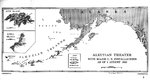
| Map of installations in the Aleutian Island Area as of 1 Aug 1942, prepared for the United States Navy Office of Naval Intelligence Combat Narrative report. Note that Attu and Kiska were listed as Japanese held. | Track chart from the shelling of Kiska Island by the cruiser USS St. Louis, 7 Aug 1942. | Map depicting the American operations on Attu Island, Aleutian Islands, US Territory of Alaska, 11-30 May 1945 | Map depicting the Allied landings on Kiska Island, Aleutian Islands, US Territory of Alaska, 15-16 Aug 1943 |
Search WW2DB

News
- » Wreck of Teruzuki Found (27 Jul 2025)
- » USS Orlean's Bow Found (22 Jul 2025)
- » The Emperor of Japan Planned to Honor WW2-era Japanese POWs in Mongolia (4 Jul 2025)
- » US State Lawmaker John Winter Caught Using Racial Slur "Jap" and Apologized (11 Jun 2025)
- » US Government Plans to Purge WW2 Information (17 Mar 2025)
- » See all news
Random Photograph
Current Site Statistics
- » 1,181 biographies
- » 337 events
- » 45,111 timeline entries
- » 1,246 ships
- » 350 aircraft models
- » 207 vehicle models
- » 376 weapon models
- » 123 historical documents
- » 261 facilities
- » 470 book reviews
- » 28,471 photos
- » 365 maps
Famous WW2 Quote
"The raising of that flag on Suribachi means a Marine Corps for the next 500 years."James Forrestal, Secretary of the Navy, 23 Feb 1945
Support Us
Please consider supporting us on Patreon. Even $1 a month will go a long way. Thank you!
Or, please support us by purchasing some WW2DB merchandise at TeeSpring, Thank you!