169 items in this album on 9 pages.
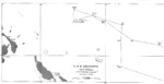 | 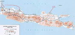 |  |  |
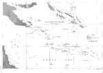
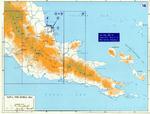
| Ship’s track for USS Lexington (Lexington-class) off Bougainville for 19-22 Feb 1942. | Map noting Japanese landings on Java, 1 Mar 1942 | Map noting the operations of the Japanese Navy First Air Fleet/Carrier Striking Force, 7 Dec 1941-12 Mar 1942 | Map showing Japanese offensives in the Dutch East Indies, Dec 1941-Apr 1942 |
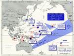 |  | 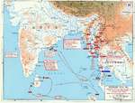 |  |
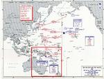
| Map noting American carrier operations, 7 Dec 1941-18 Apr 1942 | Map depicting the Japanese advance in Luzon, Philippine Islands, 10 Dec 1941-6 May 1942 | Map showing Japanese offensives in Malaya, Burma, and the Indian Ocean, Jan-May 1942 | Track of the Battle of the Coral Sea, 8 May 1942, prepared for the United States Navy Office of Naval Intelligence Combat Narrative report. |
 | 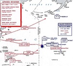 |  |  |
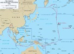
| Map depicting the Battle of Coral Sea and the Battle of Midway in May-Jun 1942 | Map of the Pacific prepared by the United States Military Academy showing the movements of the Japanese and United States battle forces for the Battle of Midway, 6 Jun 1942. | Track of the Battle of Midway, 3 to 6 Jun 1942, prepared for the United States Navy Office of Naval Intelligence Combat Narrative report. | Map of New Guinea, 1942 |
 | 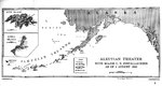 |  |  |
| Map showing the extent of Japanese advance in 1942 | Map of installations in the Aleutian Island Area as of 1 Aug 1942, prepared for the United States Navy Office of Naval Intelligence Combat Narrative report. Note that Attu and Kiska were listed as Japanese held. | Track chart from the shelling of Kiska Island by the cruiser USS St. Louis, 7 Aug 1942. | Track of the cruiser night action of 9 Aug 1942 off Savo Island, Solomon Islands where three United States cruisers and one Australian cruiser were lost. Track is taken from the USS Astoria damage report. |
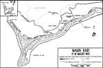 | 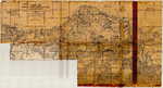 | 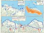 | 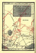 |
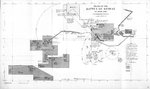
| Map of the Makin Raid, Makin Island, 17 Aug 1942 | USMC Map 104 showing the northern coast of Guadalcanal in the Lunga area | Map depicting the Guadalcanal Campaign, 7-8 Aug, 12-14 Sep, and 23-26 Oct 1942 | Map depicting Japanese and US Naval movements during the Second Naval Battle of Guadalcanal the night of Nov 14, 1942. |
169 items in this album on 9 pages.
Search WW2DB
News
- » US Women's Army Corps "Six Triple Eight" Awarded with Congressional Gold Medal (30 Apr 2025)
- » Wreck of Soviet Submarine M-49 Found (10 Apr 2025)
- » Japanese Emperor Visited Iwoto (Iwo Jima) (8 Apr 2025)
- » Race, Holocaust, and African-American WW2 Histories Removed from the US Naval Academy Library (7 Apr 2025)
- » US Government Plans to Purge WW2 Information (17 Mar 2025)
- » See all news
Random Photograph
Current Site Statistics
- » 1,167 biographies
- » 337 events
- » 44,615 timeline entries
- » 1,244 ships
- » 350 aircraft models
- » 207 vehicle models
- » 376 weapon models
- » 123 historical documents
- » 261 facilities
- » 470 book reviews
- » 28,516 photos
- » 365 maps
Famous WW2 Quote
"Since peace is now beyond hope, we can but fight to the end."Chiang Kaishek, 31 Jul 1937
Support Us
Please consider supporting us on Patreon. Even $1 a month will go a long way. Thank you!
Or, please support us by purchasing some WW2DB merchandise at TeeSpring, Thank you!