 | 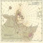 | 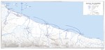 | |
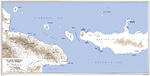
| United States Army map of the Vitiaz and Dampier Straits between Cape Cretin, New Guinea and Cape Gloucester, New Britain, 1943. | Aviation navigational Approach Map to designed guide strike aircraft to Lakunai Aerodrome at Rabaul, New Britain, Bismarck Islands. Map dated Aug 7, 1943. Note other airfields marked on the map. | United States Army map of the invasion beachhead at Aitape, New Guinea depicting the progress after the landings of 23 Apr 1944. |
Search WW2DB

News
- » US State Lawmaker John Winter Caught Using Racial Slur "Jap" and Apologized (11 Jun 2025)
- » Köln/Cologne Evacuated After Discovery of WW2 Bombs (4 Jun 2025)
- » US Women's Army Corps "Six Triple Eight" Awarded with Congressional Gold Medal (30 Apr 2025)
- » Race, Holocaust, and African-American WW2 Histories Removed from the US Naval Academy Library (7 Apr 2025)
- » US Government Plans to Purge WW2 Information (17 Mar 2025)
- » See all news
Random Photograph
Current Site Statistics
- » 1,176 biographies
- » 337 events
- » 44,933 timeline entries
- » 1,245 ships
- » 350 aircraft models
- » 207 vehicle models
- » 376 weapon models
- » 123 historical documents
- » 261 facilities
- » 470 book reviews
- » 28,469 photos
- » 365 maps
Famous WW2 Quote
"All that silly talk about the advance of science and such leaves me cold. Give me peace and a retarded science."Thomas Dodd, late 1945
Support Us
Please consider supporting us on Patreon. Even $1 a month will go a long way. Thank you!
Or, please support us by purchasing some WW2DB merchandise at TeeSpring, Thank you!