432 items in this album on 22 pages.
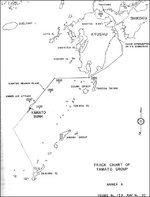 | 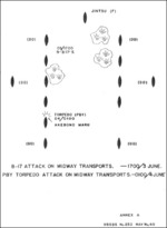 | 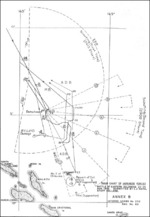 | 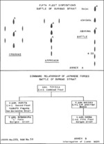 |
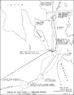
| Track chart of Yamato group, Apr 1945, part of Commander Miyamoto's interrogation, 25 Oct 1945 | Diagram showing attacks on Japanese transports during Battle of Midway, 3-4 Jun 1942; Annex A of Toyama's 1 Nov 1945 interrogation | Japanese track chart during Battle of Eastern Solomons, 23-25 Aug 1942; Annex B of Toyama's 1 Nov 1945 interrogation | Japanese Navy 5th Fleet dispositions at Battle of Surigao Strait and command structure at the battle, part of Commander Mori's interrogation, 3 Nov 1945 |
 |  | 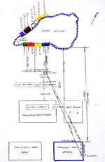 |  |
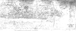
| Track of Japanese Navy 5th Fleet at Battle of Surigao Strait part of Commander Mori's interrogation, 3 Nov 1945 | Target map of Taihoku (now Taipei), Taiwan from a Dec 1945 US plan to attack Japanese-occupied Taiwan with chemical weapons | Diagram of Iwo Jima invasion beaches with lines of approach used by boats from APA Sanborn drawn by Lieutenant Commander Howard W. Whalen after WW2 | Excerpt from the 1946 United States Army Corps of Engineers map of San Pablo Bay showing the Mare Island, Vallejo, California, and the Naval Shipyard. |
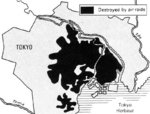 | 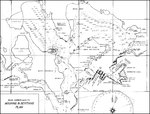 | 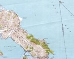 | 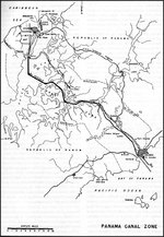 |
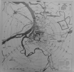
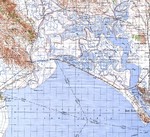
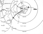
| Map depicting the results of an US government survey of bombing damage of Tokyo, Japan, 1946 | Pearl Harbor Mooring Plan, 1946 | Excerpt from the 1947 United States Geological Survey map of San Francisco Bay showing the Tiburon Peninsula. Note the Tiburon Naval Net Depot on the northeast shore. | Map of the Panama Canal Zone published in 1947 by the US Navy in “Building the Navy's Bases in World War II.” |
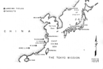 |  | 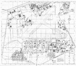 | 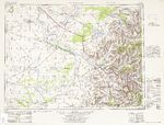 |
| US Air Force map showing Doolittle Raid targets and planned landing fields, 1 of 2 | US Air Force map showing Doolittle Raid targets and planned landing fields, 2 of 2 | June 1948 plan of Marine Corps Air Station Ewa, Oahu, Hawaii, showing its final configuration with four runways and numerous reinforced aircraft revetments. | 1950 US Army topographic map of Lamiin SĂĽme region of Manchuria in China and of Mongolia |
 | 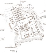 | 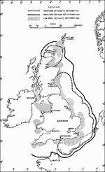 |  |
| Map of China, 1920-1950 | Map of Flossenbürg Concentration Camp drawn by engineer Stefan Kryszak who was a prisoner at the camp during the war | Map showing British radar range between Sep 1939 and Sep 1940, published in 1953 | A composite map of Mare Island Naval Shipyard, Vallejo, California, United States, 1954 Jun 30. Note that north is in the about 4:00 o’clock direction. |
432 items in this album on 22 pages.
Search WW2DB
News
- » WW2DB's 19th Anniversary (29 Dec 2023)
- » Looted Painting "Madonna with Child" Returned to Poland (2 Jun 2023)
- » Wreck of USS Mannert L. Abele Found (29 May 2023)
- » Wreck of Montevideo Maru Found (25 Apr 2023)
- » Accidental Detonation of a WW2-Era Bomb in Great Yarmouth (10 Feb 2023)
- » See all news
Current Site Statistics
- » 1,150 biographies
- » 337 events
- » 43,556 timeline entries
- » 1,239 ships
- » 349 aircraft models
- » 207 vehicle models
- » 372 weapon models
- » 123 historical documents
- » 259 facilities
- » 468 book reviews
- » 28,413 photos
- » 432 maps
Famous WW2 Quote
"The raising of that flag on Suribachi means a Marine Corps for the next 500 years."James Forrestal, Secretary of the Navy, 23 Feb 1945
Support Us
Please consider supporting us on Patreon. Even $1 a month will go a long way. Thank you!
Or, please support us by purchasing some WW2DB merchandise at TeeSpring, Thank you!