169 items in this album on 9 pages.
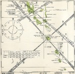 | 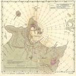 |  | 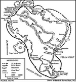 |
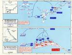
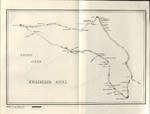
| United States Hydrographic Office July 1943 map of the New Hebrides Islands (now Vanuatu) showing friendly aircraft approach bearings. | Aviation navigational Approach Map to designed guide strike aircraft to Lakunai Aerodrome at Rabaul, New Britain, Bismarck Islands. Map dated Aug 7, 1943. Note other airfields marked on the map. | Map depicting the Allied landings on Kiska Island, Aleutian Islands, US Territory of Alaska, 15-16 Aug 1943 | Map of Vella Lavella in the Solomon Islands created by the New Zealand military depicting the troop movements during the island’s capture, Aug 1943. |
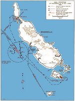 |  | 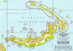 |  |
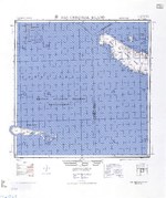
| Map noting American naval operations off Bougainville, Solomon Islands, 31 Oct-2 Nov 1943 | Map depicting the invasion of Makin and Tarawa Atolls, Gilbert Islands, 20-23 Nov 1943 | Map noting Japanese dispositions at New Britain, Bismarck Archipelago, 30 Nov 1943 | 1944 United States Army map of Choiseul Island, the northernmost of the Solomon Islands. |
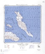 | 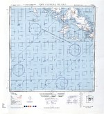 | 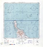 |  |
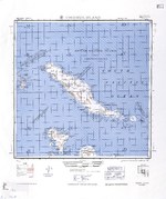
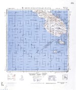
| 1944 United States Army map of Malaita Island and the eastern end of Guadalcanal in the Solomon Islands. | 1944 United States Army map of New Georgia and Rendova Islands with a portion of the Solomon Sea in the Solomon Islands. | 1944 United States Army map of northern Bougainville and Buka Island in the Bismarck Archipelago. | 1944 United States Army map of northern Santa Isabel Island in the Solomon Islands. |
 |  |  | 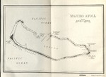 |
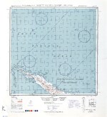
| 1944 United States Army map of San Cristobal and Rennell Islands with a portion of the Coral Sea in the Solomon Islands. | 1944 United States Army map of southern Bougainville and the Treasury Islands in the Bismarck Archipelago. | 1944 United States Navy chart of Kwajalein Atoll, Marshall Islands. | 1944 United States Navy chart of Majuro Atoll, Marshall Islands. |
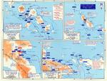 | 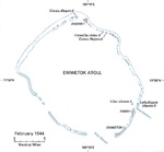 | 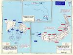 | 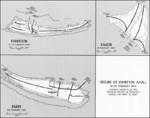 |
| Map noting engagements in the Solomon Islands and New Guinea, late 1943 to early 1944 | Feb 1944 United States Army map of Eniwetok Atoll in the Marshall Islands. | Map depicting the invasion of Kwajalein Atoll, Marshall Islands, 31 Jan-4 Feb 1944 | Map illustrating Operation Catchpole against Eniwetok, Engebi, and Parry Islands of Eniwetok Atoll, Marshall Islands, 18-22 Feb 1944 |
169 items in this album on 9 pages.
Search WW2DB
News
- » US Women's Army Corps "Six Triple Eight" Awarded with Congressional Gold Medal (30 Apr 2025)
- » Wreck of Soviet Submarine M-49 Found (10 Apr 2025)
- » Japanese Emperor Visited Iwoto (Iwo Jima) (8 Apr 2025)
- » Race, Holocaust, and African-American WW2 Histories Removed from the US Naval Academy Library (7 Apr 2025)
- » US Government Plans to Purge WW2 Information (17 Mar 2025)
- » See all news
Random Photograph
Current Site Statistics
- » 1,167 biographies
- » 337 events
- » 44,615 timeline entries
- » 1,244 ships
- » 350 aircraft models
- » 207 vehicle models
- » 376 weapon models
- » 123 historical documents
- » 261 facilities
- » 470 book reviews
- » 28,516 photos
- » 365 maps
Famous WW2 Quote
"The raising of that flag on Suribachi means a Marine Corps for the next 500 years."James Forrestal, Secretary of the Navy, 23 Feb 1945
Support Us
Please consider supporting us on Patreon. Even $1 a month will go a long way. Thank you!
Or, please support us by purchasing some WW2DB merchandise at TeeSpring, Thank you!